Posts

Showing posts with the label dumpy level

Dumpy Level And Tripod Stand

Image
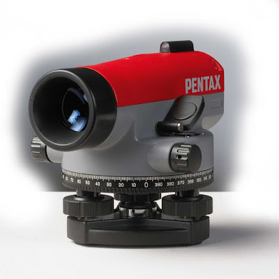
Dumpy level And Tripod Stand: A dumpy level, builder's auto level , leveling instrument, or automatic level is an optical instrument used to establish or verify points in the same horizontal plane. It is used in surveying and building with a vertical staff to measure height differences and to transfer, measure and set heights. Tripod Stand: A surveyor's tripod is a device used to support any one of a number of surveying instruments, such as theodolites, total stations, levels or transits. Uses of dumpy level: The dumpy level is mainly used in surveying for the following purposes: To determine relative height and distance among different locations of a surveying land. To determine relative distance among different locations of a surveying land. Invention: In 1832, English civil engineer William Gravatt, who had worked with Marc Isambard Brunel and his son Isambard on the Thames Tunnel, was commissioned by Mr. H.R. Palmer to examine a scheme for the South Easte...

Leica NA 332 Auto level instrument

Image
Leica NA 332 The Leica NA 332 automatic (surveyors) level has been developed for professionals who are looking for results with the highest quality day to day.With the many obstructions and uneven surfaces on construction and building sites, the NA332 optical levels coming into the picture, rise to the occasion and ensure the straightest and safest construction possible. The NA300 Series is your suitable, reliable partner for accurate measurements and high-quality results. Thanks to the ergonomic design, NA 300 Series levels are user-friendly. Add in the simple and easy handling of these levels, and you have the perfect partner on any work site. ·         Leveling Accuracy ± 1.8mm (ISO 17123-2 certified) ·         Telescope Magnification 32x ·         Minimum focus distance: < 1m ·         IP54 dust and splash water protected ·         Distin...

Auto level instruments

Image
Auto Level Instrument: An auto level, builder's dumpy level, leveling instrument, or automatic level is an optical instrument used to establish or verify points in the same horizontal plane. It is used in surveying and building with a vertical staff to measure height differences and to transfer, measure and set heights. Uses of auto level: The Auto level   is mainly used in surveying for the following purposes: To determine relative height and distance among different locations of a surveying land. To determine relative distance among different locations of a surveying land. Invention of Auto level: In 1832, English civil engineer William Gravatt, who had worked with Marc Isambard Brunel and his son Isambard on the Thames Tunnel, was commissioned by Mr. H.R. Palmer to examine a scheme for the South Eastern Railway's route from London to Dover. Forced to use the then conventional Y level during the work, Gravatt devised the more transportable and easier ...